
News
| The sea water temperature calculated using the PM3D hydrodynamic model is updated daily on the basis of current remote-sensing data during data assimilation. As this process is continuous, the water temperatures calculated using the model do not diverge significantly from those measured in situ in the sea. Maps of water temperature in the Baltic with a resolution of 1 km are obtained by the spatial interpolation of the PM3D model results, the spatial resolution of which is from ca 0.9 km in the southern Baltic to ca 1.9 km elsewhere in this sea. Vertical temperature distributions are modelled for 18 layers of differing thickness, so the water temperatures at different depths can be calculated. The SO SatBałtyk service gives water temperatures in the Baltic in degrees Celsius [°C], four times daily. |  An example of the surface temperature distribution of the Baltic Sea calculated by the model PM3D. An example of the surface temperature distribution of the Baltic Sea calculated by the model PM3D. |
The methodology of determining water temperature using the PM3D model The three-dimensional PM3D hydrodynamic model (Parallel Model 3D) is a version of the numerical [1] M3D model, modernized within the framework of the SatBałtyk project, which is based on the POM (Princeton Ocean Model). As a result of the parallelization of the calculations performed on computers equipped with multi-core processors and the implementation of procedures for assimilating satellite data, the PM3D enables a more accurate calculation of water temperatures and other water parameters at high resolution. Information about the weather is supplied from the UM numerical weather model (Unified Model) operating at ICM with a resolution of 4 km. Over the entire Baltic Sea the PM3D model has a resolution of 1 nautical mile (ca 1.9 km). However, this model enables the resolution to be increased for certain areas with two-way downscaling, which means that the water temperature can be calculated at a resolution of 0.5 nautical miles (ca 0.9 km) in the southern Baltic (see figure). The PM3D works operationally, assimilating incoming satellite data on SST determined from AVHRR or MODIS radiometers in cloudless regions. The model takes into account the inflow of solar radiation calculated using current satellite data from the SolRad model. |
 An example map of water temperature of the Baltic Sea with spatial resolution An example map of water temperature of the Baltic Sea with spatial resolution |
Validation (assessment of accuracy) The PM3D model has been validated many times with respect to various parameters and regions [2] [3]. The accuracy of water temperature determined using PM3D was evaluated on the basis of the temperature difference calculated using the model with measurements made by automatic measurement buoys (see the Figure) and at shore stations. The statistical error, expressed as the standard deviation of these differences, is estimated at 0.86 °C in open Baltic waters (measurement buoys) and 1.2 °C for the shore stations. The systematic errors (the mean differences) are 0.39 and -0.5°C respectively. |
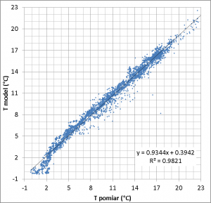 Comparision of modelled and empirical values of surface temperature of the Baltic Sea, regression equation, R2-coefficient of determination Comparision of modelled and empirical values of surface temperature of the Baltic Sea, regression equation, R2-coefficient of determination |
Interesting phenomena visible on temperature maps
|
|

|
Powstańców Warszawy 55 81-712 Sopot, Poland |
|
Write to us: |


